Alaska Highway 75th Anniversary Celebration
  • Home
  • Alaska Highway History
  • Communities
    • Beaver Creek
    • Dawson Creek
    • Delta Junction
    • Fort Nelson
    • Fort St John
    • Haines Junction
    • Teslin
    • Tok
    • Watson Lake
    • Whitehorse

The Alaska Highway

Lodges, Legends & Lives

-by Tim Bell

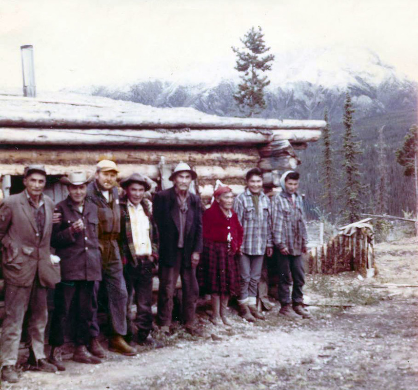
Lakeview Lodge circa 1950 - Photo Courtesy Ft Nelson NRRM Public Library Historical Project

Take a Stroll Through The Alaska Highway's Historical Mile Posts 

 
My name is Tim Bell and I have been playing and working on the Alaska Highway most of my life. I moved to Muncho Lake with my parents in 1959. We operated Lakeview Lodge at mile 462 near the shores of this beautiful lake. Because Muncho Lake school only went to grade 8, I left to continue my education. Once I completed school, I returned to the Alaska Highway and sold advertising. For the past 50 years I’ve worked for and owned several guide books. Currently I publish a Yukon Map an Alaska State Map  and three Northern publications; The Alaska Highway Mapbook, The Alaska Mapbook, The Inside Passage Mapbook. These Maps and Guides to Alaska are available on our website www.bellsalaska.com. This website also has information on all the highways in and around Alaska, the Yukon and Northern BC. For a comprehensive list of the best things to do in Alaska visit our site.
I have compiled the following about the history of the Alaska Highway’s lodges and owners from memory and I apologize in advance for any errors or omissions. I love the Alaska Highway and its people as I believe they epitomize the strength and courage of our forefathers. I hope you enjoy this stroll down memory lane and please do not hesitate to contact me with personal stories that I might add or corrections to my text. I will continue to add to this story as I find new and interesting facts about this fascinating Highway.
A special thanks to Sylvia Bramhill from the Fort Nelson - NRRM Public Library Historical Project (check it out on FaceBook), Lloyd Kostuick who has lived in Watson Lake for over 65 years and many others who have provided me with this information. Happy 75th birthday to the Alaska Highway, which I still consider my Home.  
Picture
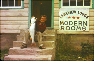
Mile 462 - Guy, the Lakeview Lodge Mechanic
Photo Courtesy Ft Nelson NRRM Public Library Historical Project
Picture
Mile 233 - Lum Abner 
Picture
Mile 462 - Joe Bell
Mile 0
Dawson Creek was the muster point for the American, and Canadian troops and the many contractors who built this amazing road. The highway was completed in only nine months and was considered one of the engineering marvels of modern times. The troops that came through Dawson Creek pushed the road through to mile 588, Contact Creek, where they met with troops coming south from Whitehorse. This was a truly wilderness trail at this point in time and troops spent many months and years continually improving it. The social and economic impact of this highway would change northern Canada and its people forever.
Mile 16.5 (km 27) South access to the Kiskatinaw bridge
​
There were many timber bridges built by civilian workers on the Alaska Highway, the Kiskatinaw Bridge is the only one still in use. It is also one of the most unusual, curving nine degrees along its 162.5 metre (534 foot) length.
In 1978, a new road was built that bypassed the bridge and, so secured the survival of this important historical landmark. Kiskatinaw Provincial Park has camping in treed sites and also provides access to the river. There are good views of the bridge's construction from below.
Mile 32 (km 55) Peace River Bridge 
​
The original Peace River Bridge was built in 1942 by the US Public Roads Administration as part of the wartime construction of the Alaska Highway. At the time of its opening it was considered one of the great bridges in the Dominion of Canada. The bridge was hit by a landslide and collapsed on October 16, 1957. All traffic that was headed north was diverted first onto a ferry and when that proved unreliable, onto the railroad bridge. The construction of a new highway bridge was completed in 1959.
Mile 33 (km 56) Taylor sits on the bank of the mighty Peace River. It was named after Donald Herbert Taylor, who homesteaded here in 1896. He met his wife to be, Charlotte, and they stayed in the area to raise a family. They operated a ferry service across the Peace River for many years. The Peace River Bridge was constructed in 1942 as part of the Alaska Highway construction.
Mile 48 (km 75) Ft St John
Ft St John was originally established near its current location in 1794 as a trading post. It has moved several times and is now a vibrant city that is the service center for the vast oil and gas reserves in the North. In 1942 the population was approximately 200 in Fort St. John and shortly thereafter it exploded to over 6000 troops during the building of the Alaska Highway.

Mile 49
This area was known as Alcan camp. It was here that many of the private contractors and military who were involved in the building of the Alcan had their headquarters.

Mile 53 (km 86) Charlie Lake Memorial
​The Charley Lake Memorial stands in recognition to honor the lives lost on May 14th 1942. Seventeen men from the 341st engineer Regiment boarded a pontoon boat at the south end of Charley Lake, intending to carry supplies to company E’s temporary camp on the north end of the Lake. The water was very rough and the winds were strong. Around noon that day, the boat was hit by several waves and capsized. A local homesteader saw the accident and was able to rescue five of the 17 men aboard. The monument beside Charley Lake is constructed of stainless steel and consists of 12 posts, one for each of the soldiers who lost their lives.
Mile 73 Beatton River Airstrip
The Beatton River airstrip was built as part of the Northwest Staging Route which was the air equivalent of the Alaska Highway. Airstrips were constructed approximately every hundred miles along the planned route of the Alaska Highway. The route extended from Montana through Alberta, British Columbia, the Yukon and Alaska all the way into Siberia.

Mile 101 (km 162) Wonowon / Blueberry Control Station.
​
This was a 24-hour controlled checkpoint operated by the U.S. Army. This was also the site of Blueberry Esso, one of the first highway lodges on the Alcan. Blueberry Esso was run by Dave Pierce and his family for many years.
Mile 148 (km 233)  Suicide Hill.
Site of the Infamous Suicide Hill. It is here somebody posted the sign “Prepare to meet thy Maker.” This extremely steep hill was one of many obstacles along this section of the highway. There are several estimates as to how steep the grade was and one of them says it was 32%. Yikes!
Mile 162 (km 256) Sikanni Chief River Bridge.
This is where one of the most interesting tales about the building of the Alaska Highway took place. In 1942 the American army was still segregated, yet approximately 30% of the 11,000 men sent north to build the Alaska Highway were African-American. These troops were segregated from their white counterparts and even restricted to their camps. They were poorly housed, with insufficient clothing, poor food and they were given the left over construction equipment after the white troops got theirs. They were challenged by their officers to build a bridge over the Sikanni River in five days. The soldiers of the 95th black Regiment bet their paychecks that they could do this. They accomplished this incredible feat in only three days and because of feats like this and other heroic measures, the African-American soldiers won recognition from their commanders and from the rest of the Army. These troops performed amazingly well with all things considered and after the completion of the highway they were deployed to Europe and the South Pacific in combat roles, which was a first. The army was desegregated in 1948 by President Roosevelt.

Mile 178 
​If you're heading northwest and look up to your right, you'll see the old Alaska Highway that leads up Trutch Mountain. The decision was made in 1942 to go up the hill versus trying to build through the muskeg in the Minaker River Valley. The summit of Trutch Mountain is over 4000 feet and is at historical mile 191. Trutch was the second highest summit on the Alcan Highway. The current highway follows the River valley.
Trutch Mountain Lodge was built here and was operated by Don Peck and family. Don owned a guide and outfitting hunting company operating from the lodge. Ross, one of Don’s sons, took over the family business and then sold it to Larry and Lori Warren. Larry had worked for Don for several years and also for another legend of the Alaska Highway, Dennis Callison. More about Dennis Callison later. Ross still lives in the North, near Hudson’s Hope. 

 Mile 233 Lum n Abners Lodge
This is the location of historic Lum n Abner's Highway Lodge. It was one of the original lodges on the highway. It was opened in 1952. The story I heard was that it’s named for a famous radio show from the 40s. The Lodge closed in 2006. A small First Nations community has settled here.

Mile 234  Adsett Creek
The highway from here to mile to 275 was known as the Prophet River curves. There were approximately 140 of them and it took almost 2 hours to drive this section of the highway. The curves were eliminated by highway reconstruction in 1992.

Mile 300 (km 454) Ft. Nelson
This was and still is a major stop-over point on the Alaska Highway. It was called Zero by the troops and construction workers that were here because it was the start of two major highways; the Alcan to Whitehorse, and the Simpson Trail to Ft Simpson in the Northwest Territories. Fort Nelson was established in 1805 by the North West Fur Trading Co and was the fifth fort site established by them. The Canadian government built the airport in 1941, as part of the Northwest Air Staging Route. The community was home to only 200 people prior to the construction of the Alaska Highway and then approximately 2,000 soldiers arrived all at once. There is an excellent visitor reception center and a transportation Museum worth visiting. Be sure to stop by the Ft. Nelson Library and check out the “NRRM Historical Archives.” This amazing project is being compiled to honor and preserve the lives and the legends of the people of this Region.
Mile 352
The remnants of Steamboat Mountain Lodge, which has been closed for several years, can be seen from the highway.

mile 392 (km 598) Summit Lake is the highest point on the Alaska Highway. The Lodge on the left (when heading north) was opened in the early 50s by Frank and Del Steele. It had several owners and eventually closed for good in the mid-90s. There is an excellent provincial campground beside the lake.
Picture
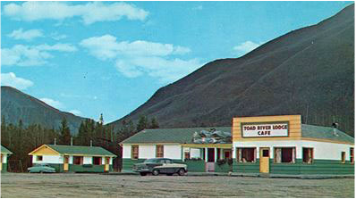
Mile 422 Toad River - Photo Courtesy Ft Nelson NRRM Public Library Historical Project
Mile 422 (km 647) Toad River Lodge 
Toad River was also known as Camp 138. The A.E. Jupp Construction Company of York Ontario was based here in 1942 and was responsible for building this portion of the Highway. There was also a landing strip for the Northwest staging route. The Toad River Lodge is one of the best-known lodges on the Alaska Highway. It was originally opened by Dennis Callison when the Highway became a public road. Dennis was one of the guides for the engineers of the PRA (Public Roads Administration) in 1941 and fell in love with the area and stayed. He and his wife Marg and children Gloria and Janice lived here at the same time I lived at Muncho. Toad River Lodge has had several owners since it was built but has consistently offered quality service to the travelling public. The lodge is currently owned by Matthew Roy and Darrel Stevens and is known for great food and a collection of over 10,000 hats.
Picture
Mile 442 - The MacDonald Family
Photo Courtesy Ft Nelson NRRM Public Library Historical Project
Picture
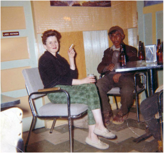
Alice Bell & Charlie MacDonald
Picture
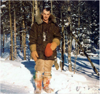
Mile 442 - Tony Money
Photo Courtesy Ft Nelson NRRM Public Library Historical Project
Mile 442
​
The remains of a highway lodge known as “The Village” are to the west of the Hwy. It was here I met famous British author and wilderness explorer, Anton Money, who was living here in the late 50’s. This is also close to the traditional home of the MacDonald clan. This First Nations family hunted, trapped and lived here since the mid 1800s. Charlie McDonald was one of the guides that assisted the PRA in the routing of the Alaska Highway from Steamboat Mountain to Lower Post in the Yukon. The lives of the MacDonald clan are beautifully documented in a collectible book called “The McDonald's” by Allison Tubman a great granddaughter of Charlie and Nellie.

Mile 456 (km 698) Muncho Lake
 Here the engineers faced one of the most difficult sections of highway to build. Several attempts were made to avoid building a road along the lake. In the end it was decided that the lakeshore route was the most viable. When I lived here in the late 50’s and early 60’s, there was a highway maintenance camp as well as a Canadian National Telecommunications camp. We had a school with 28 children, one teacher, Mrs Taylor, and eight grades. There was a curling rink and a hall we used for the occasional movie and dances.

Mile 462
​This is where my parents operated a highway lodge known as Lakeview Lodge. This lodge was on the east side of the highway. It burned in November 1962 and was never rebuilt. It was originally built by Charlie and Sophie Brandt. Highland Glen Lodge was across the highway and was one of the first purpose built Lodges to serve the increasing tourism market. Most of the Lodges along the way were constructed using abandoned army buildings. Highland Glen was built by an irascible Scotsman named Jim Grant. Jim and Betty ran the lodge for many years and eventually sold and retired. The lodge is now Northern Rockies Lodge and is one of the most beautiful lodges on the highway.

Muncho Lake was home to Pete Peterson, who came to the area in 1933. Mount Peterson and Peterson Creek are named after him. He also helped the PRA with selecting a route for the Highway. I was fortunate to be able to spend much of my time growing up with Pete. He taught me to hunt, fish, and to have a great appreciation of nature and my surroundings. 
Mile 463
During the time I lived at Muncho there were two lodges at mile 463, John and Marion Wiebe’s Wilderness fishing camp, and Muncho Lake Lodge. John and Marion's became J&H Wilderness and was closed several years ago. Muncho Lake Lodge was originally operated by Tom and Rose Mould. It also had several owners, including Gunter and Mary Tauers. It was closed for several years but recently reopened as a campground by Brian McDonald and Joanne Middleton. Both are long time residents of the North and, like me, are graduates of the school at Muncho Lake. Brian is the grandson of Charlie and Nellie McDonald and spent much of his youth travelling the backcountry of this beautiful area.


Mile 495 (km 763) Liard River Bridge
The Liard River Bridge is the only remaining suspension bridge on the Alaska Highway. It was built in 1943 during the construction of the Alaska Highway. Much of the steel used in the bridge came from the Tacoma Narrows Bridge which collapsed in 1940 due to faulty engineering. The Tacoma Narrows Bridge was famously known as Gallopin Gertie because of the vertical movement of the bridge deck during high winds, which eventually led to its collapse.

Mile 496 (km 765) Liard Hotsprings Lodge
One of the most famous stops on the Alaska Highway is the Liard River Hot Springs. It is shown on old maps as far back as the middle1800s. We used to drive up from Muncho in the middle of winter and snowshoe into the pools for a swim. There have been several lodges in this area, including Liard River Lodge, which has been open intermittently over the past 20 years and Liard Hot Springs Lodge, which was originally known as Trapper Rays and is currently open.

Mile 514 (km 792) Smith River Bridge
Smith River Bridge and Falls is found to the east. A 1.6 mile gravel road leads to parking near the falls. There is good grayling fishing at the base of the falls. The flight strip at Smith River was one of the designated landing strips on the Northwest staging route. Approximately 20 miles northeast of here lies Million-Dollar Valley, the site of a multiple aircraft crash. In January 1942, a flight of Martin B 26 marauder bombers left Edmonton, Alberta to fly to Siberia. During the course of the flight three of the bombers were separated from their group and with worsening weather conditions were forced to find an area to crash land. The landings were relatively successful and the men were able to set up a camp. They were rescued a couple of days later when they were spotted by a flight of P40 fighter aircraft also headed for Siberia. The survivors were evacuated to Watson Lake and the planes and equipment were abandoned. There was an extraordinary effort made to recover the engines and the guns from these bombers including flying in a disassembled Caterpillar tractor to help. Two of the fuselages were also recovered in 1971. For more information check online for “Million Dollar Valley” 
Mile 543 (km 840) Fireside Lodge
Fireside Lodge was opened in the early 50s and has seen many changes. The original lodge burned in a forest fire in 1982 and was subsequently rebuilt. It’s currently closed but you may notice the food prep trailer on the property is from the hit Canadian TV show, Corner Gas.

Mile 588 (km 909) Contact Creek 
Contact Creek. It was here on September 24, 1942 that the soldiers of the 36th Regiment coming from the south and the 340th Regiment from the North met. This completed the southern portion of the Alaska Highway.

Mile 590 (km 912) Contact Creek Lodge
Contact Creek Lodge was built across the highway from the original 340
th Regiment construction camp. This was originally a Trappers cabin owned by Hector Kostuick. Hector built it in 1932 and trapped in the area for over 30 years. When the Army came through in 1942, He was instrumental in helping find a suitable route for the Highway. He put in a gas pump and started offering services during the summers. Richard and Denny Hair bought the Lodge in 1984 and have operated it ever since.
Mile 620 (km 957) Lower Post
Lower Post is a First Nations community that was originally known as Fort Liard. A trading post was established here in 1872 by Robert Sylvester. Subsequently, it was taken over by the Hudson Bay Company, after a truce was arranged between the warring Kaska Dena and the Taku First Nations. This was another of the landing strips on the Northwest Staging route.
Mile 627
The highway crosses into the Yukon from British Columbia for the last time. There are several previous crossings of the border between Contact Creek and here.

Mile 635 (km 978) Watson Lake
Watson Lake is named after Francis Gilbert Watson. He first came to the Yukon, with his father, in 1898 on the way to the Klondike Gold Rush. Unlike most prospectors, Frank and his Dad found gold and had a successful mine near Dawson City. They were flooded out in 1905 and decided to return to Lake Tahoe. Several years later, Frank returned to the area travelling through Wrangell, Alaska and up the Stikine River,
it was here he met a Kaska native woman named Adela Stone. They were married and settled in the area and raised a family. Watson Lake became a supply center for the building of this section of the highway.
The Sign Post Forest was begun by Carl Lindley, a homesick G.I. who put up a sign to his hometown of Danville, IL It has grown into the area’s most famous attraction with over 70,000 signs now on display.
Mile 642 Upper Liard
The Upper Liard area has been a First Nations settlement for thousands of years.
Mile 710 Rancheria Lodge
In 1946 the British Yukon Navigation Company which was a division of the White Pass and Yukon Railroad operated bus service between Whitehorse and Dawson Creek. Because there were limited services along this pioneer road, BYN financed the building of four lodges so passengers and drivers would have a place to stop. Rancheria was one of these, and as such was one of the first lodges to open on the highway. Bud Simpson helped build the log lodge in 1946 and eventually bought it. He and his wife Doris ran the lodge for almost 30 years. It is still a favorite stopping place for many Alaska Highway travellers.

Mile 717 The Message Post
I don't remember the names of the people that started this Lodge but they had a unique idea. They placed the large signboard at the front of the property and encouraged travellers to leave messages for friends who were also travelling the Highway. It closed in the 1990s after a fire.

Mile 733 (km 1137) Swift River Highway Maintenance Camp and Swift River Lodge
The Lodge has been closed for several years. It was one of the original stopovers for the bus route that serviced the highway starting in 1947.

Mile 777 Morley River Lodge
The Lodge was originally built by Clyde Wann, one of the Yukon's most famous entrepreneurs. He also owned Swift River Lodge, Beaver Creek Lodge at mile 1202, and worked at Destruction Bay at mile 1083. He also started the first commercial airline in the Yukon, Yukon Airways in 1927. You can learn more about this Yukon entrepreneur at the Yukon Transportation Museum in Whitehorse.
Mile 804 (km 1244) The Village of Teslin
The Teslin Tlingit people are descended from the Taku Quan who moved inland from Southeast Alaska in the early 18th century. They gradually expanded their base to include people who lived on the Yukon Plateau. They maintained their social and economic ties with the coast and they were the first people to introduce Russian, American and European trade goods to the Yukon.

Although there was contact with other First Nations people along the Alaska Highway. This was the first time an organized group of First Nations came into contact with the Army. The influence of the construction of the highway brought about drastic change and prompted the semi nomadic Tlingit population to permanently settle in what is today the village of Teslin. Even with all the outside influence they firmly established a distinct society and became known as the Inland Tlingit. Teslin has a grocery store, motels, restaurants, campgrounds and fuel. The Teslin Tlingit Heritage Center is world-class facility, so don’t miss it while passing through.
Mile 835 (km 1294)
The Canol pipeline project to bring oil from Norman Wells in the Northwest Territories to Whitehorse has been described as the biggest waste of time, energy and money during the construction of the Alaska Highway. The concept was to be able to have a safe supply of oil for the military in Alaska. A refinery was shipped in from Texas and assembled near Whitehorse. The output of the refinery was only 3000 barrels a day which was far less than was needed so the project was scrapped shortly after completion.

Mile 836 (km 1296) Johnson's Crossing
​Johnson's Crossing Lodge
was built by Robert Porsild soon after the highway opened to the public, it has been a gathering place since the mid-40s. Some of my fondest memories were sitting at the back kitchen table watching Ellen Davignon, the owner, prepare her world-famous cinnamon buns. Ellen was the daughter of Robert and Elly Porsild and she grew up at Johnson's Crossing. She and her husband Phil operated the Lodge until the mid-90s when they sold. They raised their family and provided a great experience to the travelling public for over 45 years. Ellen is a well known Yukon author and still lives in Whitehorse. Johnson's Crossing was sold in 2013 and reopened the next year after extensive renovations. 
Mile 866 (km 1342) Jake's Corner
As with most highway lodges it started out as a construction camp. The highway splits here with one route leading to Carcross and the other to Whitehorse. The tale I’ve heard was that Col. Jacobson, the commander, did not like to go to Carcross to get to Whitehorse and proceeded to build a more direct route. The original Lodge was built by Roy Chaykowski and operated as the Crystal Palace for many years. It had luxurious accommodation and an indoor heated swimming pool.

Mile 910 McCrae
There were several construction camps in this area. You’ll notice this is right by the train tracks, used by
the White Pass and Yukon Railroad for transporting much of the material, men and equipment for the building of the Alaska Highway from Skagway, Alaska.
Mile 918 (km 1420) Whitehorse
In 1942 Whitehorse was best known as a transportation hub in the Yukon. Dawson city was still the capital because of its importance in gold mining. When the construction crews and the military arrived everything changed. Whitehorse was incorporated as a city in 1950 and the capital was moved here from Dawson in 1953. Whitehorse has great restaurants, good accommodation, campgrounds, and lots of things to do. It is home to several excellent museums; the Copperbelt Railway and Mining Museum, the McBride Museum, Beringia Interpretive Center, and the Yukon transportation Museum.

Mile 974 Champagne
The section of the highway from Whitehorse to Haines Junction was one of the easiest to build. There was very little muskeg and there was an existing wagon road used since the early 1900s. The Champagne Aishihik First Nations have lived in the area for thousands of years and acted as guides for the troops that were building the highway in 1942.

There is great interest in the area since there have been several archaeological finds, including a naturally mummified body, which is been carbon dated to between 300 and 550 years old. He is known as “Canadian Ice Man.”
Mile 1016 (km 1579) Haines Junction
​The Junction of the Alaska Highway & the Haines Highway. The Haines Highway is an excellent 160 mile road that leads to Haines Alaska. It was constructed to facilitate the movement of troops and supplies from the coast to the Alaska Highway. It is one of the most beautiful and scenic highways in the North. This easy three-hour drive to the city of Haines Alaska is highly recommended.

Mile 1053
A two mile road leads to Silver City. This may be the Yukon's largest ghost town. Gold was discovered here in the early 1900s and over the next several years a small community developed including a permanent post for the RCMP. Supplies destined for further up the lake were put on barges here and shipped to Burwash Landing. When the Army arrived in 1942 they continued that practice. Most of the land in Silver City is private so please be respectful.

Mile 1061 Soldier Summit
The site that commemorates where the official opening ceremony for the Alaska Highway took place on November 20, 1942.
​Mile 1083 (km 1685) Destruction Bay
Destruction Bay got its name when a huge wind storm blew through the area, destroyed several structures and building material, during the construction of the highway.

Mile 1093 (km 1701) Burwash Landing
Burwash Landing is one of the oldest communities in the Yukon. The Jaquot brothers built a trading post here in 1904. Leland Allinger purchased the Lodge from the Jaquots around 1952. The first time I came to Burwash was in 1959 to visit the owners of the lodge, Leland and Betty Allinger. Betty was known as a great cook and her specialty was lake trout. In 1982 they sold to Ole and Helen Wirth who ran it till 2012 when it was sold to the Kluane First Nations and subsequently closed. The Kluane Museum of History in Burwash Landing showcases wildlife exhibits, First Nations tools and weapons and Yukon minerals.

Mile 1117
There is a memorial placed here to Lieut. Roland Small who was killed in accident during the building of the highway.

Mile 1118 Kluane Wilderness Village
Kluane Wilderness Village, one of the largest lodges on the Alaska Highway was owned and operated by John Trout. John was a gold miner as well and spent many years prospecting the area. The Lodge closed in the 90s after John's death.


 Mile 1127 Mountain View Lodge
Mountain View Lodge was another of my favorite places. The view from the Lodge up the valley to Canada's tallest peak, Mount Logan is spectacular. The Lodge was owned by Sid Vandermeer for many years and was closed in the 1990s. Sid still lives in the area and is the manager of the Yukon Visitor Center in Beaver Creek.

Mile 1130 (km 1761) Donjek River Bridge
The original site of this bridge was about 3 miles upriver. This was a very difficult river crossing because of the width and the type of soil found here. My dad, Joe Bell, worked on the original bridge as a young man.

Mile 1163 Koidern River Fishing Lodge
Koidern River Fishing Lodge was owned and operated by Jim and Dorothy Cook. It has been closed for several years.

Mile 1167
White River Crossing was a U.S. Army construction camp. I believe the first private operator of the Lodge was Danny Nolan. He is also well-known for starting the Yukon Wildlife Preserve near Whitehorse. The Bradley family purchased the property from Danny and Tom and Norma Bradley ran it for many years. It is now owned and operated by Amanda Harris and is called Discover Yukon. It is an excellent stopover point.

Mile 1202 (km 1870) Beaver Creek
Beaver Creek and area has been inhabited by First Nations for over 10,000 years. The White River First Nations are closely related to the upper Tanana Peoples from Alaska and the Tachone People from south and east of Beaver Creek. It has a good range of visitor services and is the largest community between Whitehorse and Tok

Mile 1221 U.S.A /Canada Border
The Alaska Highway crosses the U.S./Canada International Border.


Mile 1271 Northway Airport
Another link on the Northwest Staging Route.

Mile 1292
The EM Duesenberg Company from Clear Lake Iowa was one of the general contractors that worked on this section of the highway.

Mile 1314 Tok Alaska
Before the building of the Alaska Highway the community of Tok did not exist. Although there is some controversy about how the name of the community was chosen, it appears to have been named in 1942. One story is that it was the name of Husky pup owned by a construction worker, while others claim the name came from the Athabascan word for water. Tok’s economy today is based on tourism and serving the travelers on the Alaska Highway. It is a friendly place inhabited by people that wouldn't want to live anywhere else.

Mile 1361 Dot Lake
Dot Lake has been home to the Athabascans for over 10,000 years. There was a trail that extended north to the Yukon River. During the building of the Alaska Highway there was a construction camp called Sears City located here. Fred Vogel was one of the first white settlers in the area. He built a lodge, school, post office and church.

Mile 1422 Delta Junction
The end of the Alaska Highway. Here the Alaska Highway joins the Richardson Highway that connects Valdez and Fairbanks. The junction is approximately 8 miles south of Big Delta where most of the previous development had taken place, including Rika’s Roadhouse. Alan Army air base, which was part of the Northwest Staging Route, was constructed about 5 miles south of the Junction and this created more reasons to expand the current Township. Delta Junction has a history of boom and bust and is one of the most interesting communities in Alaska. From the building of the Alaska Highway, to the trans-Alaska pipeline, and a massive missile defense installation at Fort Greeley, Delta Junction has seen it all. More recently tourism has played a major part in Delta as well as the development of the Pogo Gold mine.
Back To Top
Website Powered by Bell's Travel  Gudies
Picture
  • Home
  • Alaska Highway History
  • Communities
    • Beaver Creek
    • Dawson Creek
    • Delta Junction
    • Fort Nelson
    • Fort St John
    • Haines Junction
    • Teslin
    • Tok
    • Watson Lake
    • Whitehorse